104 results
Latin printable images
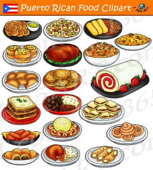
Puerto Rican Food Clipart
Puerto Rican Food - meals and dishes clipart in both color and black and white versions of each graphic! This set contain 38 clip art files for you to educate your students are create a menu of foods from Puerto Rico! Food included in this set are mofongo, pastelon, bacalaitos, empanadillas, brazo gitano and much more.There are 19 full color and 19 black and white graphics, giving you 38 files in all. Each file is approximately 300 DPI and in transparent PNG format. Files will be downloaded in a
Subjects:
Grades:
PreK - 12th
Also included in: Latin American Food Clipart Bundle #1
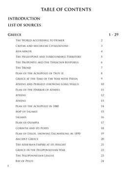
Historical Maps of the Ancient World
A .pdf book that collects various historical maps of the ancient world. Over 80 maps included, with full table of contents and a brief introduction to the maps. The book is divided into three sections: Greece, Rome, and Other Empires, and the maps range from as wide as the world as the ancients saw it and the full Mediterranean basin to as specific as cities and archaeological sites. Perfect for any study of the ancient world, but especially ancient Greece (Athens, Persian Wars, Trojan War), anc
Subjects:
Grades:
3rd - 12th, Higher Education, Adult Education
Types:
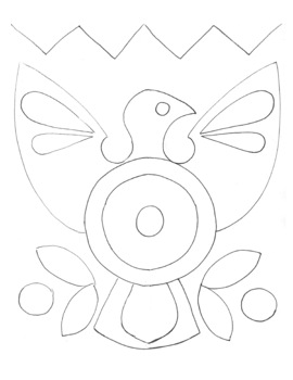
Yarn Art Template
Template for a study on Central American Latin Art History, specifically Huichol yarn art. Glue yarn in circular patterns to fill each shape.
Subjects:
Grades:
1st - 8th
Types:
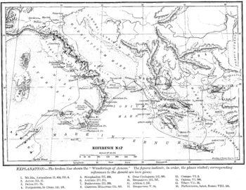
Wanderings of Aeneas Map
A map of Aeneas' wanderings through the Mediterranean from Troy to Italy as described by Vergil / Virgil in his Aeneid.
All images carry the Creative Commons Attribution-NonCommercial-ShareAlike 4.0 International License. That means that, upon the purchase of these images, you are free to share them, i.e. copy and redistribute the material in any medium or format or adapt them, i.e. remix, transform, and build upon them. But this sharing and adapting cannot be applied to any commercial use of t
Subjects:
Grades:
3rd - 12th, Higher Education, Adult Education
Types:
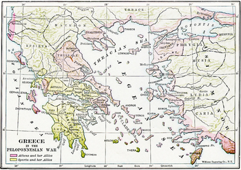
Map of Ancient Greece during the Peloponnesian Wars
A detailed map in color of ancient Greece and the Ionian Peninsula (Turkey) during the Peloponnesian Wars, detailing which cities were allied with Athens and which with Sparta. A high quality .jpg, 600 dpi, and at least 10" x 10" in size, which makes it suitable for printing as well as projecting (unlike many images available on the net).
All images carry the Creative Commons Attribution-NonCommercial-ShareAlike 4.0 International License. That means that, upon the purchase of these images, you
Subjects:
Grades:
3rd - 12th, Higher Education, Adult Education
Types:
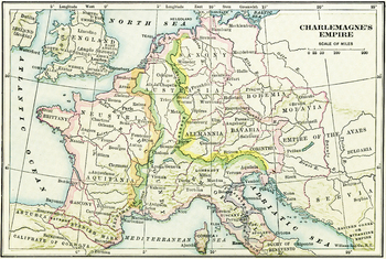
Map of Charlemagne's Empire
A map of Charlemagne's Empire. The first Holy Roman Emperor, crowned by the Pope in 800, Charlemagne united Europe during a mini-Renaissance, spearheaded by his court scholar Einhard. A high quality .jpg, 600 dpi, and at least 10" x 10" in size, which makes it suitable for printing as well as projecting (unlike many images available on the net).
All images carry the Creative Commons Attribution-NonCommercial-ShareAlike 4.0 International License. That means that, upon the purchase of these image
Subjects:
Grades:
3rd - 12th, Higher Education, Adult Education
Types:
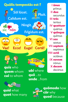
Latin Poster with Weather, Question Words, Numbers and TPRS Phrases
This Latin poster includes basic weather phrases, question words, TPRS emotional reaction phrases, and cardinal and ordinal numbers 1-10. You can send the file to businesses like Walgreens or Office Depot to print the poster in any size you wish, and you can also print it out as an individual quick reference page for your students.
From daily warmups to storytelling and comprehension activities, my students always enjoy having this colorful reference at their disposal!
Subjects:
Grades:
Not Grade Specific
Types:
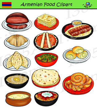
Armenian Food Clipart
Armenian Food - meals and dishes clipart in both color and black and white versions of each graphic! This set contain 26 clip art files for you to educate your students are create a menu of foods from Armenia! Food included in this set are Manti, Lula kebab, Khash, Boerag and much more.There are 13 full color and 14 black and white graphics, giving you 26 files in all. Each file is approximately 300 DPI and in transparent PNG format. Files will be downloaded in a zip folder file. The zip file co
Subjects:
Grades:
PreK - 12th
Also included in: European Food Clipart Bundle #2
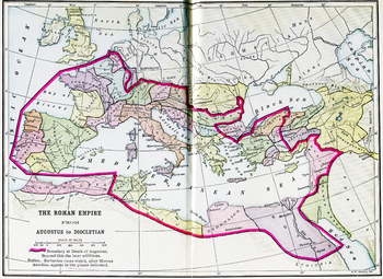
Color Map of the Roman Empire from Augustus to Diocletian
A color map of the Mediterranean with the border of the Roman Empire during both Augustus' and Diocletian's reign is clearly delineated. A high quality .jpg, 600 dpi, and at least 10" x 10" in size, which makes it suitable for printing as well as projecting (unlike many images available on the net).
All images carry the Creative Commons Attribution-NonCommercial-ShareAlike 4.0 International License. That means that, upon the purchase of these images, you are free to share them, i.e. copy and re
Subjects:
Grades:
3rd - 12th, Higher Education, Adult Education
Types:
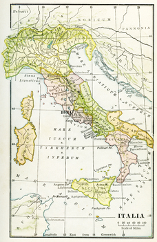
Color Map of Ancient Italy
A color map of Ancient Italy with labels in Latin and Rome labeled prominently. A high quality .jpg, 600 dpi, and at least 10" x 10" in size, which makes it suitable for printing as well as projecting (unlike many images available on the net).
All images carry the Creative Commons Attribution-NonCommercial-ShareAlike 4.0 International License. That means that, upon the purchase of these images, you are free to share them, i.e. copy and redistribute the material in any medium or format or adapt
Subjects:
Grades:
3rd - 12th, Higher Education, Adult Education
Types:
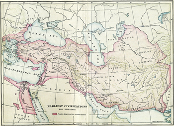
Earliest Civilizations Map
A map of the Near East, showing the earliest civilizations of the west, with the Persian Empire highlighted. Bactria, Assyria, Mesopotamia, and others are shown. A high quality .jpg, 600 dpi, and at least 10" x 10" in size, which makes it suitable for printing as well as projecting (unlike many images available on the net).
All images carry the Creative Commons Attribution-NonCommercial-ShareAlike 4.0 International License. That means that, upon the purchase of these images, you are free to sha
Subjects:
Grades:
3rd - 12th, Higher Education, Adult Education
Types:
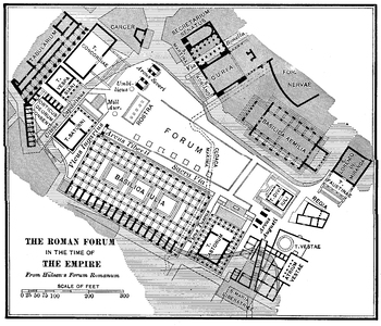
Roman Forum in the Time of the Empire Plan
A detailed plan of the Roman Forum during the Empire, including in it the Basilica Julia, the Rostra, the Basilica Aemilia, the Curia, and the temples at the northwestern corner, among others. A high quality .jpg, 600 dpi, and at least 10" x 10" in size, which makes it suitable for printing as well as projecting (unlike many images available on the net).
All images carry the Creative Commons Attribution-NonCommercial-ShareAlike 4.0 International License. That means that, upon the purchase of th
Subjects:
Grades:
3rd - 12th, Higher Education, Adult Education
Types:
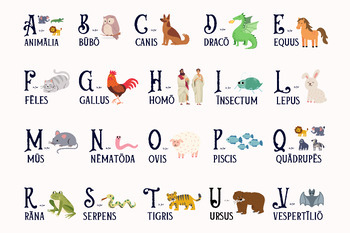
Latin alphabet animal poster: A is for animalia | Latin classroom decor
This animal-themed alphabet poster is a fun way to build vocabulary, facilitate target language use, and cultivate a language-rich environment in your Latin classroom. A is for animālia! Letters from the Classical Latin alphabet as used during the Late Republic / early Empire are represented (so no J, K, W, X, Y, Z). This is a high quality (300 dpi) png image that can be used for a large (24x18 inch) or extra large (48x36 inch) poster. If you prefer individual letter posters, see my listing here
Subjects:
Grades:
Not Grade Specific
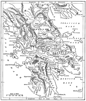
Map of Ancient Greece
A detailed map of ancient Greece. A high quality .jpg, 600 dpi, and at least 10" x 10" in size, which makes it suitable for printing as well as projecting (unlike many images available on the net).
All images carry the Creative Commons Attribution-NonCommercial-ShareAlike 4.0 International License. That means that, upon the purchase of these images, you are free to share them, i.e. copy and redistribute the material in any medium or format or adapt them, i.e. remix, transform, and build upon th
Subjects:
Grades:
3rd - 12th, Higher Education, Adult Education
Types:
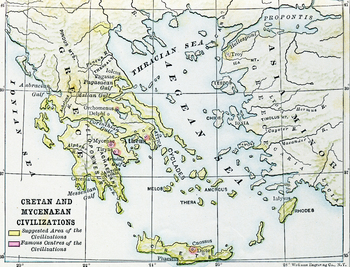
Civilizations of Crete and Mycenae Map
A map of the ancient Aegean, highlighting the Mycenean and Minoan civilizations, centered at Mycenae and Crete, home of Agamemnon, Minos, the Minotaur, Daedalus, etc.. A high quality .jpg, 600 dpi, and at least 10" x 10" in size, which makes it suitable for printing as well as projecting (unlike many images available on the net).
All images carry the Creative Commons Attribution-NonCommercial-ShareAlike 4.0 International License. That means that, upon the purchase of these images, you are free
Subjects:
Grades:
3rd - 12th, Higher Education, Adult Education
Types:
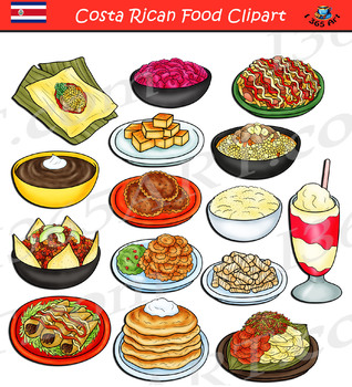
Costa Rican Food Clipart
Costa Rican Food - meals and dishes clipart in both color and black and white versions of each graphic! This set contain 30 clip art files for you to educate your students are create a menu of foods from Armenia! Food included in this set are tamal, chifrijo, salchipapa, vigoron and much more.There are 15 full color and 15 black and white graphics, giving you 30files in all. Each file is approximately 300 DPI and in transparent PNG format. Files will be downloaded in a zip folder file. The zip f
Subjects:
Grades:
PreK - 12th
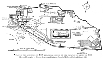
Plan of ancient Athens' Acropolis
A plan of ancient Athens' acropolis, including the Parthenon, the Erectheum, the Propylea, and the museum.
All images carry the Creative Commons Attribution-NonCommercial-ShareAlike 4.0 International License. That means that, upon the purchase of these images, you are free to share them, i.e. copy and redistribute the material in any medium or format or adapt them, i.e. remix, transform, and build upon them. But this sharing and adapting cannot be applied to any commercial use of the images.
F
Subjects:
Grades:
3rd - 12th, Higher Education, Adult Education
Types:
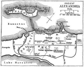
Map / Plan of Ancient Alexandria
A map of the ancient Egyptian city of Alexandria, home to the most famous library in the ancient world. A high quality .jpg, 600 dpi, and at least 10" x 10" in size, which makes it suitable for printing as well as projecting (unlike many images available on the net).
All images carry the Creative Commons Attribution-NonCommercial-ShareAlike 4.0 International License. That means that, upon the purchase of these images, you are free to share them, i.e. copy and redistribute the material in any me
Subjects:
Grades:
3rd - 12th, Higher Education, Adult Education
Types:
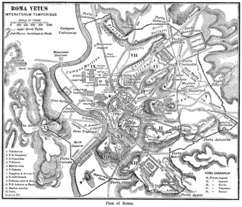
A Keyed Map of Ancient Rome during the Time of the Emperors
A detailed map of Imperial Rome, with 18 buildings identified by key, and the regions of the ancient city identified. A high quality .jpg, 600 dpi, and at least 10" x 10" in size, which makes it suitable for printing as well as projecting (unlike many images available on the net).All images carry the Creative Commons Attribution-NonCommercial-ShareAlike 4.0 International License. That means that, upon the purchase of these images, you are free to share them, i.e. copy and redistribute the materi
Subjects:
Grades:
3rd - 12th, Higher Education, Adult Education
Types:
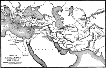
Map of the Empire of Alexander the Great
A map showing the extent of Alexander the Great's empire at its height, from Greece in the West to Persia and India in the West. A high quality .jpg, 600 dpi, and at least 10" x 10" in size, which makes it suitable for printing as well as projecting (unlike many images available on the net).
All images carry the Creative Commons Attribution-NonCommercial-ShareAlike 4.0 International License. That means that, upon the purchase of these images, you are free to share them, i.e. copy and redistribu
Subjects:
Grades:
3rd - 12th, Higher Education, Adult Education
Types:
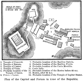
Plan of the Roman Forum and Capitoline during the Republic
A plan of the early Roman Forum as well as the Capitoline hill with the probable locations of various structures identified. A high quality .jpg, 600 dpi, and at least 10" x 10" in size, which makes it suitable for printing as well as projecting (unlike many images available on the net).
All images carry the Creative Commons Attribution-NonCommercial-ShareAlike 4.0 International License. That means that, upon the purchase of these images, you are free to share them, i.e. copy and redistribute t
Subjects:
Grades:
3rd - 12th, Higher Education, Adult Education
Types:
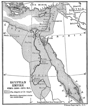
Map of the Egyptian Empire
A map of the Egyptian Empire, c.1000 BCE, focusing on the Nile and the Nile Delta. Location of the pharoahs, pyramids and mummies, Egypt was one of the most dominant empires of the Mediterranean. A high quality .jpg, 600 dpi, and at least 10" x 10" in size, which makes it suitable for printing as well as projecting (unlike many images available on the net).
All images carry the Creative Commons Attribution-NonCommercial-ShareAlike 4.0 International License. That means that, upon the purchase of
Subjects:
Grades:
3rd - 12th, Higher Education, Adult Education
Types:
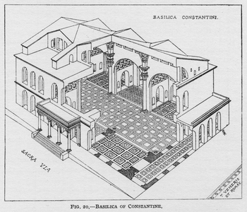
Reconstruction of the Basilica of Constantine
High quality, print-quality, drawing of a cutaway reconstruction of the Basilica of Constantine with the Sacra Via and the Temple of Venus and Rome identified as well.
All images carry the Creative Commons Attribution-NonCommercial-ShareAlike 4.0 International License. That means that, upon the purchase of these images, you are free to share them, i.e. copy and redistribute the material in any medium or format or adapt them, i.e. remix, transform, and build upon them. But this sharing and adapt
Subjects:
Grades:
1st - 12th, Higher Education, Adult Education
Types:
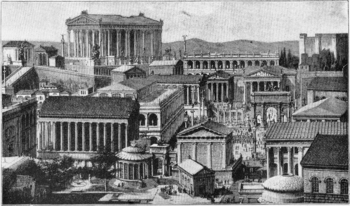
Reconstruction of the Roman Forum
A reconstruction of Rome's forum, looking toward the Capitoline with the Temple of Vesta in the foreground. A high quality .jpg, 600 dpi, and at least 10" x 10" in size, which makes it suitable for printing as well as projecting (unlike many images available on the net).
All images carry the Creative Commons Attribution-NonCommercial-ShareAlike 4.0 International License. That means that, upon the purchase of these images, you are free to share them, i.e. copy and redistribute the material in an
Subjects:
Grades:
3rd - 12th, Higher Education, Adult Education
Types:
Showing 1-24 of 104 results

