TPT
Total:
$0.00

United States Coordinate Graphing Pictures BUNDLE All 50 States

Rated 5 out of 5, based on 18 reviews
5.0 (18 ratings)
;
Grade Levels
5th - 9th, Homeschool
Resource Type
Standards
Formats Included
  • Zip
Pages
13 for each State
$95.00
List Price:
$162.50
You Save:
$67.50
Bundle
$95.00
List Price:
$162.50
You Save:
$67.50
Bundle
Share this resource
Report this resource to TPT

Products in this Bundle (51)

    showing 1-5 of 51 products

    Description

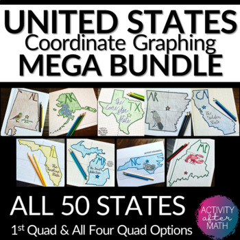
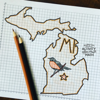
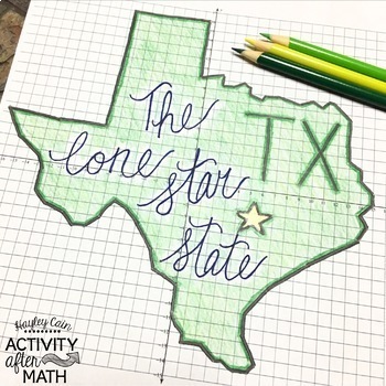
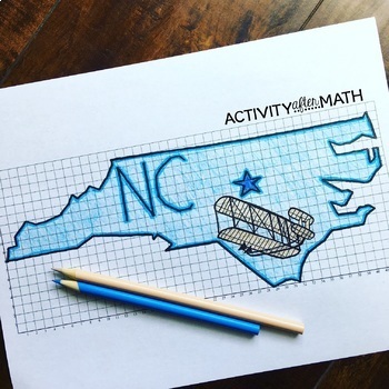
    HUGE BUNDLE Need a way to use math while learning about the different states? Students will graph points on a coordinate plane and it creates an outline of the State. There is also a star on the state Capital and the state's abbreviation. The clever titles of the state’s nickname gives them a clue to what the picture will be.

    ★Want to know some tips to use these in ALL subjects? Click here to read my Blog Post !★

    I have included Student Instructions for both Quadrant One ONLY and instructions that include ALL four Quadrants! This is a great way to differentiate for your lower-level learners as well as your higher-level learners.

    The points include ordered pairs with decimals such as (10, 4.5) and (-0.5, -1.5).

    This resource includes:

    For each version:

    • A blank outline of the graph to use as an answer key.
    • A colored example of the finished picture.
    • Student Instructions with the ordered pairs.
    • A graph with the numbers and x- and y-axis labeled.
    • A graph with the fractional grid lines labeled.

    --See below for links to ALL 50 STATES:

    1. Alabama

    2. Alaska

    3. Arizona

    4. Arkansas

    5. California

    6. Colorado

    7. Connecticut

    8. Delaware

    9. Florida

    10. Georgia

    11. Hawaii

    12. Idaho

    13. Illinois

    14. Indiana

    15. Iowa

    16. Kansas

    17. Kentucky

    18. Louisiana

    19. Maine

    20. Maryland

    21. Massachusetts

    22. Michigan

    23. Minnesota

    24. Mississippi

    25. Missouri

    26. Montana

    27. Nebraska

    28. Nevada

    29. New Hampshire

    30. New Jersey

    31. New Mexico

    32. New York

    33. North Carolina

    34. North Dakota

    35. Ohio

    36. Oklahoma

    37. Oregon

    38. Pennsylvania

    39. Rhode Island

    40. South Carolina

    41. South Dakota

    42. Tennessee

    43. Texas

    44. Utah

    45. Vermont

    46. Virginia

    47. Washington

    48. West Virginia

    49. Wisconsin

    50. Wyoming

    51. United States FREEBIE

    Options for using this resource:

    It is easy to print the points on one side and the graph on the back side to save paper! This is a great beginning of the year activity, End of the Year, Substitute, "filler days", early finisher activity, and anchor activity!

    This is hand drawn, not computer generated, so the points graphed work out exactly as the picture looks!

    My students love to graph this and color it with their own designs! It makes a great bulletin board display! Have your students create this in collaboration with your other content areas while teaching about the states!

    **Click here to view ALL the states

    You may also be interested in the following:

    Sudoku Bulletin Board Kit Interactive

    Tessellation Project Art In Math End of the Year Activity

    6th 7th 8th Grade Math Vocabulary Crossword Puzzles MEGA BUNDLE

    Holiday Coordinate Graphing Pictures BUNDLE

    Don't forget that leaving feedback earns you points toward FREE TPT purchases.

    © Hayley Cain (Activity After Math) Please note - this resource is for use by one teacher only. Additional teachers must purchase their own license. If you are interested in purchasing several licenses, please contact me. Thank you for your feedback and Happy Teaching! 

    hayley@activityaftermath.com

    Let's be Social

    Follow me on Instagram

    Follow me on Facebook

    Check out my Blog

    Total Pages
    13 for each State
    Answer Key
    Included
    Teaching Duration
    N/A
    Report this resource to TPT
    Reported resources will be reviewed by our team. Report this resource to let us know if this resource violates TPT’s content guidelines.

    Standards

    to see state-specific standards (only available in the US).
    Use a pair of perpendicular number lines, called axes, to define a coordinate system, with the intersection of the lines (the origin) arranged to coincide with the 0 on each line and a given point in the plane located by using an ordered pair of numbers, called its coordinates. Understand that the first number indicates how far to travel from the origin in the direction of one axis, and the second number indicates how far to travel in the direction of the second axis, with the convention that the names of the two axes and the coordinates correspond (e.g., 𝘹-axis and 𝘹-coordinate, 𝘺-axis and 𝘺-coordinate).
    Draw polygons in the coordinate plane given coordinates for the vertices; use coordinates to find the length of a side joining points with the same first coordinate or the same second coordinate. Apply these techniques in the context of solving real-world and mathematical problems.

    Reviews

    Questions & Answers