
Maps of the United States of America - Montessori color-code


Montessori Print Shop
6.6k Followers
Grade Levels
1st - 4th, Homeschool
Subjects
Resource Type
Formats Included
- PDF
Pages
7 pages
Montessori Print Shop
6.6k Followers
Also included in
 All maps in this World Maps Bundle are color-coded using the traditional Montessori map colors. They are excellent control maps for children using the traditional wooden Montessori maps.Continent maps are in full color and include:blank outline mapcolor maplabeled outline maplabeled color mapCapitalPrice $40.00Original Price $54.50Save $14.50
Description
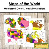
Maps of the United States of America -
Includes the following maps of the United States:
- 1 black & white blank map
- 1 black & white labeled map
- 1 colored blank map
- 1 colored and labeled map
- set of map labels for the large wooden puzzle map
Maps print on 8½ x 11″ paper and follow the traditional Montessori map colors.
The pin flags that accompany these maps can be found here.
The color-coded pin flags that accompany these maps can be found here.
You may be interested in USA Capital Cities Control Map and Master.
Total Pages
7 pages
Answer Key
N/A
Teaching Duration
N/A
Report this resource to TPT
Reported resources will be reviewed by our team. Report this resource to let us know if this resource violates TPT’s content guidelines.
Reviews
Questions & Answers
6.6k Followers
