Finding Speed with Maps - OHIO 5TH GRADE SCIENCE
VIZSLAMOM
38 Followers
Grade Levels
3rd - 8th
Subjects
Resource Type
Standards
CCSS5.MD.A.1
CCSS5.G.A.1
CCSS5.G.A.2
Formats Included
- Word Document File
Pages
2 pages
VIZSLAMOM
38 Followers
Description
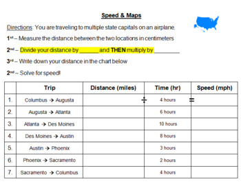
Use any map you want! Students pretend they are flying on a plane to different state capitals. They will measure the distance in cm and then convert to miles based on YOUR map's scale.
Students solve for speed & rank each trip based on how fast the plane was moving. Students create a bar graph to show their results!
Total Pages
2 pages
Answer Key
N/A
Teaching Duration
N/A
Report this resource to TPT
Reported resources will be reviewed by our team. Report this resource to let us know if this resource violates TPT’s content guidelines.
Standards
to see state-specific standards (only available in the US).
CCSS5.MD.A.1
Convert among different-sized standard measurement units within a given measurement system (e.g., convert 5 cm to 0.05 m), and use these conversions in solving multi-step, real world problems.
CCSS5.G.A.1
Use a pair of perpendicular number lines, called axes, to define a coordinate system, with the intersection of the lines (the origin) arranged to coincide with the 0 on each line and a given point in the plane located by using an ordered pair of numbers, called its coordinates. Understand that the first number indicates how far to travel from the origin in the direction of one axis, and the second number indicates how far to travel in the direction of the second axis, with the convention that the names of the two axes and the coordinates correspond (e.g., 𝘹-axis and 𝘹-coordinate, 𝘺-axis and 𝘺-coordinate).
CCSS5.G.A.2
Represent real world and mathematical problems by graphing points in the first quadrant of the coordinate plane, and interpret coordinate values of points in the context of the situation.


