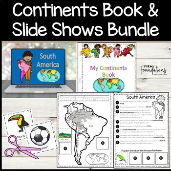
Continents Book and Slide Shows- PDF Continents Book and PPT or Google Slides
- Zip
- Google Apps™

Products in this Bundle (2)
Bonus
Description
This is a bundle that includes a Continents Book that students make as a guided, interactive activity after they view the 7 Continents and 5 Oceans Slide Shows.
For each continent studied, the teacher reads facts about the continent and instructs students on how to color in the continent map. Students also cut and paste pictures in their continents books that highlight famous landmarks, geographical features, and popular animals for each continent.
To prepare this activity, the teacher will need to make a copy of the continents book for each student. The teacher also needs to print a copy of the "Cut and Paste" pages for each student to guide students through the coloring, cutting, and pasting.
The accompanying slide shows (available as Google Slides or PowerPoint presentations) contain real-life photos for the facts that the teacher reads to the students. The slide shows also include directions that take students step-by-step through the completion of the Continents Book.
This Continents Book is intended to give young students a general overview of each continent. See below for highlights of countries, landmarks, and geographical features mentioned during the study of each continent.
Continents Book & Slide Show Highlights:
1. Continents Song- Students learn a simple song to name all 7 continents while they point to the continents on an accompanying world map.
2. World Map- Students color each continent a different color as they learn about the continents.
3. North America- Canada, United States, Mexico, Central America, Caribbean Islands, Greenland, Niagara Falls, Inuit, Grand Canyon, Statue of Liberty, Chichén Itzá, polar bear, moose, red-eyed tree frog
4. South America- Brazil, Amazon Rainforest, Amazon River, Peru, Andes Mountains, soccer, Machu Pichu, llama, jaguar, macaw, toucan, sloth
5. Europe- Ural Mountains, United Kingdom, France, Italy, Germany, Big Ben, Eiffel Tower, Leaning Tower of Pisa, Neuschwanstein Castle, hedgehog, pine marten, brown bear, Eurasian wolf
6. Asia- China, India, Mount Everest, Great Wall of China, Taj Mahal, giant panda, Bengal tiger, snow leopard, king cobra
7. Africa- Egypt, Kenya, Nile River, Sahara Desert, Mount Kilimanjaro, Great Sphinx, pyramids, camel, elephant, zebra, giraffe, lion
8. Australia- Great Barrier Reef, Uluru/Ayers Rock, Aboriginal peoples, Sydney Opera House, kangaroo, koala, platypus
9. Antarctica- explorers, South Pole, iceberg, penguin, leopard seal, blue whale, killer whale
10. 5 Oceans- On the last page of the Continents Book, students trace the names of the 5 Oceans- Arctic, Atlantic, Indian, Pacific, and Southern.
For updates on future freebies, educational resources, and sales, please follow my store by clicking here.


