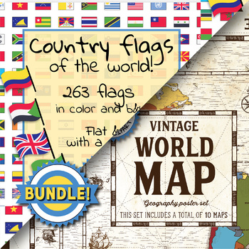
Country flags of the world & World map and continent - School Clip Art - BUNDLE
- Zip
What educators are saying
Products in this Bundle (2)
Description
BUNDLE! Country flags of the world & World map and continent
Product #1: Link to the product
Country flags of the world: 263 Country flags. HUGE clip art BUNDLE!
This clip art contains 263 flags, in 2 forms (flat and with mast) in color and black & white line art.
Contains all the flags of the countries of the world : 195 Countries.
Look at the complete list of flags by downloading the preview
A total of 1052 clips!
Included:
263 color flag (flat) clip art flag set- PNG format
263 B&W flag (flat) clip art set- PNG format
263 color flag (with mast) clip art set- PNG format
263 B&W flag (with mast) clip art set - PNG format
PDF Compilation of 263 world flags - ready-to-print - in color and black and white
PDF Flag list - ready-to-print
2 HUGE Flag Poster (Size A2 16.5 x 23.4 in) in PDF and JPG (One with only the 195 countries)
Slides for presentation - 263 slides with name - ready-to-print - PDF file
2 Flags Background (One with only the 195 countries)
All flag images are high quality PNG format, 300 dpi.
All flag files are named for convenience. The PDF Flags list has the country name added to the flag page.
Perfect for educational projects and teaching resources.
______________________________________________________
Product #2: Link to the product
World map and continents: vintage style geography poster set
This world and continents set includes a total of 10 maps:
• World
• Africa
• South America
• Central America
• North America
• Europe (2)
• Middle East
• Asia
• Oceania
Maps capture current geographical and political boundaries (as of May 2019) with vintage-style graphics and script. The world map clearly labels continents and oceans. Continent maps label all countries, oceans and include a color-coded country key.
These maps are a great addition to any geography or social studies lesson! Use them as classroom decor, or incorporate in presentations, lessons, worksheets, or quizzes.
Keywords: flags, flag, countries, nations, lands, world, international, commercial use, pictures, clip art, clipart, bundle, maps, mao, vintage, continent, poster, set.
The images are high resolution (300 DPI) for high quality printing. Files are provided in pdf format. For personal or commercial use.


